Edit Geo-Spatial Index
![]()
![]()
|
Edit Geo-Spatial Index |
|
|
|
|
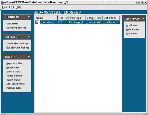
Editing a geo-spatial index in the load definition file in the Load Definition File editor consists of the following steps:
Step 1
The first step is to select the Geo-Spatial Index task in the INDEXES task bar along the left side of the load definition file editor to activate the GEO-SPATIAL INDEXES page if it isn't already activated.
Step 2
The second step is to either double-click the geo-spatial index to be edited or select the geo-spatial index and click the Edit Index task in the GEO-SPATIAL task bar along the right side of the GEO-SPATIAL INDEXES page:
The Edit Geo-Spatial Index dialog box will appear:
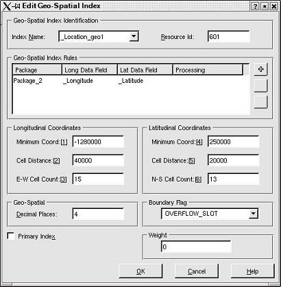
The Edit Geo-Spatial Index dialog box is composed of the following components:
Geo-Spatial Index Identification
|
Component |
Description |
|
Unique name to identify the index. The drop-down list contains a list of suggested unique names. Either select a name from this list or you can specify your own. | |
|
Unique integer to identify the index. A resource id will be automatically assigned to the index when it is created. |
Index Rules
|
Component |
Description |
|
Name of the package across which the index is being created. | |
|
Name of the longitude data field across which the index for the rows of the grid is created. | |
|
Name of the latitude data field across which the index for the columns of the grid is created. | |
|
Used to support conditional processing of an index on a document by document basis. | |
|
|
Use the add button to open the Add Geo-Spatial Index Rules dialog box. |
|
|
Select an index rule and click the delete button to remove an index rule from the list. |
|
|
Select an index rule and click the edit button to open the Edit Geo-Spatial Index Rules dialog box. |
Longitudinal Coordinates
|
Component |
Description |
|
The smallest longitude mapped by the grid. | |
|
Longitudinal distance in fractional degrees mapped by an individual grid cell. | |
|
Number of cells in a single east-west row of the grid. |
Latitudinal Coordinates
|
Component |
Description |
|
The smallest latitude mapped by the grid. | |
|
Latitudinal distance in fractional degrees mapped by an individual grid cell. | |
|
Number of cells in a single north-south row of the grid. |
Geo-Spatial
|
Component |
Description |
|
Identifies the number of implied decimal places for the longitudinal minimum coordinate, latitudinal minimum coordinate, longitudinal cell distance and the latitudinal cell distance. For any geo-spatial grid this value must be nonzero. |
Boundary Flag
|
Component |
Description |
|
Select how values that fall below the base value or above the grid limits are handled. |
Weight
|
Component |
Description |
|
Applied to results returned using this index. |
Primary Index
|
Component |
Description |
|
If this box is checked, the index will be set as the primary index for all packages defined in the Index Rules. |
Step 3
The third step is to edit the information that needs to be changed. In this case the boundary flag has been changed:

After the information has been edited, click the OK button to apply the changes.
The geo-spatial index has been edited.
|
|
|
 (Add)
(Add) (Delete)

